
please empty your brain below
|
This route is my regular bus route. I don't really mind the change, but I do find the justification of "serving an area previously remote from the bus network" a little bit of a stretch.
Before this change people living on this part of fish island had either a short walk to the existing Monier Road stops, a short walk to the White Post Lane stopes or a short walk across the pedestrian footbridge to the stops by the primary school in the Park. They were hardly remote from the network
Also the new routing means the 339 no longer serves Hackney Wick station.
Stephen | 20.11.23 - 7:26 a.m. | #
|
|
I trust you also offer brewery tours for TfL parties
Ian J | 20.11.23 - 7:56 a.m. | #
|
|
I'm glad someone is showing this sort of work the diligence it requires. Just a shame it's not the people who have the power to make the changes!
JP | 20.11.23 - 8:13 a.m. | #
|
|
I found it difficult to read todays post as the print is a lot fainter in contrast to the background than yesterday.
Robert | 20.11.23 - 8:21 a.m. | #
|
|
Too long, too faint, too niche; didn’t read.
David B | 20.11.23 - 8:33 a.m. | #
|
|
Too long, too faint, too niche; didn’t read.
David B | 20.11.23 - 8:33 a.m. | #
|
Also very confusingly, on the page for the 339 on the TfL website, if you click "map view", they haven't removed the old no longer served section, instead they've just added the new section alongside it.
So it looks like the 339 goes round in a circle round Hackney Wick and Fish Island.
IE3I writes: Unintended omission. Added, thanks.
Charlie | 20.11.23 - 8:47 a.m. | #
|
|
In my part of town changes to the 485 route last March were previewed with on board announcements. Unfortunately more than 6 months on they're still being played and the bus changes page they suggest we check no longer includes the 485. In fact given the March date I expect occasional travellers think it's March 2024 given that's now closer.
ap | 20.11.23 - 8:50 a.m. | #
|
|
It looks as though the bus stop at Monier Road is saying "Oh", but perhaps, because of the poor preparation for the changes, it really ought to be saying "Oh no!"
Petras409 | 20.11.23 - 8:51 a.m. | #
|
Dear Independent E3 Inspectorate,
Ditto Robert's you may like to know your body copy is illegible & nearly invisible on phone, whereas on a laptop text appears bigger and more openly kerned than usual. All the best
Noel | 20.11.23 - 8:51 a.m. | #
|
How do you know that there is a 'Stadium Event' - again the assumption seems to be 'everyone's got a smartphone, they'll know'.
You missed one, the map correctly lists Wansbeck Road as one of the roads no longer served by the 339, but the written description says Wick Lane.
Still Anon | 20.11.23 - 9:17 a.m. | #
|
Noel and Robert, yes me too.
So sadly I couldn't read today's post.
Just letting you know.
Joho | Homepage | 20.11.23 - 9:18 a.m. | #
|
|
DG (sorry, Independent E3 Inspectorate), please go back in a week or so and let us know if any of these errors, physical or online, have been corrected!
MikeK | 20.11.23 - 9:52 a.m. | #
|
|
The bus stops on Carpenters Road are regularly used for filming.
David | 20.11.23 - 9:52 a.m. | #
|
|
Wondering if bus stop L is going to become the new bus stop M!
Cornish Cockney | 20.11.23 - 11:38 a.m. | #
|
Just for completeness, I wish to report that the independent inspector's text is perfectly readable on my galaxy phone.
I did wonder whether the typeface was chosen to resemble that produced by a manual typewriter, and if so, what that implies.
Malcolm of Kent | 20.11.23 - 1:36 p.m. | #
|
I’ve been an advocate for public transport all my life, and have not owned a car for the last 15 years. And yet, In a months time, I’m purchasing a new car.
Not because my needs have changed, or my beliefs, but because it has become quite clear to me that transport operators, local authorities and government no longer give a damn about it.
Buses and trains are expensive, unreliable and communication to paying passengers is virtually non-existent.
Nearly every journey is now a tour de force of incompetence and carelessness.
It’s such a far cry from many of our European neighbours.
Lew | 20.11.23 - 2:18 p.m. | #
|
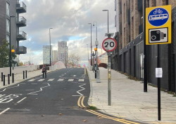
Blue 'bikes and buses only' signs have now been uncovered at both ends of the bridge, with a camera warning underneath.
No other changes are evident.
Independent E3 Inspectorate | Homepage | 20.11.23 - 3:00 p.m. | #
|
|
Hard to see the need for the bridge or the bus diversion.
Mike Jones | 20.11.23 - 4:13 p.m. | #
|
Since I happened to be in London on Saturday I made a detour to ride on the newly diverted 339. There didn't seem to be much confusion from the passengers on my bus although there was one woman who by the sounds of it may have got off a couple of stops earlier than she needed to out of uncertainty about the new routing.
Also, because I took a longer journey than just the new bit (specifically, I went from Stepney Green to Stratford station) I was able to notice that one of the stops in Stepney also appeared as "*" on the display so that particular problem was not isolated to the Olympic Park stretch.
X-Plaistow | 20.11.23 - 5:02 p.m. | #
|
|
Did you use to write reports like this for a living? And have you sent a copy to your local Councillor, your local GLA member and the Mayor? An interesting follow-up post would be about the responses you receive. You're welcome.
south london lad | 20.11.23 - 6:46 p.m. | #
|
|
This is quality stuff. I hope we get more of IE3I's work in the future. Also loving the recent diversity of typefaces used.
TW | 20.11.23 - 6:50 p.m. | #
|
Passenger information seems to be an afterthought at TfL nowadays sadly. The timetable for route 10 is still up at Selfridges towards Marble Arch on Oxford Street for instance! Real-time info is just as hopeless, for example, the roadworks which have caused havoc on Central London routes at Trafalgar Square ended early yet the 'real-time' information online and on the app still displays it. Better than no information at all in the first place I suppose.
I was under the impression that iBus data was also used by TfL to monitor route performance and samesuch so a bit odd that it wasn't updated in time.
matthieu1221 | 20.11.23 - 9:30 p.m. | #
|
|
Does this mean Sidings Street has now got proper bus stops, rather than two rusty signs (one of which has disappeared)? I hope this means the buses now have the route programmed rather than * on the display..
Chris | 22.11.23 - 5:31 p.m. | #
|
|
Thanks for sharing!
Tim | Homepage | 27.11.23 - 10:23 a.m. | #
|
|
|
TridentScan v2.10.0 | Privacy Policy
|