
please empty your brain below
|
How about the Thames Clippers for a quick(ish) nip from one side to the other? Not strictly a ferry, but an option maybe?
dg writes: There are at least ten different ways to cross obliquely by River Bus, but I've missed those out.
Waterhouse | 03.10.16 - 7:05 a.m. | #
|
|
You can also cross the River Thames by foot at Barnes.
John | 03.10.16 - 7:05 a.m. | #
|
One addition for you: there's a ferry from North Greenwich to Trinity Buoy Wharf. (Weekday daytimes only)
http://www.trinitybuoywharf.com/visit-us
martin | 03.10.16 - 7:05 a.m. | #
|
The railway bridge under which the University Boat Race passes is usually known as Barnes Bridge (not Chiswick)
You've also missed Twickenham Road Bridge (after Richmond) and one of the Jubilee Line tunnels (it should read Overground, Jubilee, DlR, Jubilee, Jubilee, DLR, Crossrail)
Have you taken into account the latest changes to bus routes over Hammersmith Bridge + difficult to keep up I know.
Timbo | 03.10.16 - 7:22 a.m. | #
|
|
Bus 283 has not crossed the Thames since May
| 03.10.16 - 7:33 a.m. | #
|
|
There's a footbridge adjacent to the Fulham rail bridge too.
Simon | 03.10.16 - 7:51 a.m. | #
|
|
I think there are two Golden Jubilee bridges, one on each side of Hungerford railway bridge.
Andrew-R | 03.10.16 - 7:56 a.m. | #
|
|
Updated, thanks. At least one of you has been checking far too carefully.
diamond geezer | Homepage | 03.10.16 - 7:59 a.m. | #
|
|
Still not enough crossings in the East, now being made worse by the closure of Tower Bridge until the end of the year. 😳
Jo W | 03.10.16 - 8:07 a.m. | #
|
Eastern London certainly needs more river crossings now as there has been so much development in the area recently.
Of course the river is and was easier to span in the West being much narrower.
John | 03.10.16 - 8:35 a.m. | #
|
WEST Footbridge:(Diamond Jubilee) Battersea - Chelsea Harbour -Battersea
dg writes: Added, thanks.
Grumpy Anon | 03.10.16 - 9:20 a.m. | #
|
|
Did you know that during the WWII, there were two emergency bridges built ? They were from Victoria Embankment to County Hall and at Millbank. They were built in 1942 in case enemy action took out other bridges and were demolished in 1948.
Jimbo | 03.10.16 - 9:28 a.m. | #
|
What better follow on from yesterday's post about the East London cross-Thames bus service, than this one showing the glaring disparities in public transport provision along the different stretches of the river.
If I've counted correctly, these are the numbers of bus *routes* providing a connection between north and south.
West: more than 50
Central: more than 60
East: 1
Downstream: 1
It'd be less laughable if the solitary service for the East was anything to cheer about, but from everything written yesterday... :(
RogerW | 03.10.16 - 10:13 a.m. | #
|
|
To show the true imbalance betweeen east and west, it might be worth indicating which crossings are free to use and which ones cost money (or are planned to cost money soon, e.g. Blackwall).
Mike Scott | 03.10.16 - 10:14 a.m. | #
|
|
I wonder where Joanna Lumley lives?
MOTB | 03.10.16 - 10:15 a.m. | #
|
|
@ Jimbo: there's 45 seconds of British Pathe film of one of them being taken down (https://youtu.be/EWEkUjX1RVA) & also of a Bailey bridge being deconstructed at Windsor: https://youtu.be/_GbPfE9_DcE
Old Buccaneer | 03.10.16 - 10:20 a.m. | #
|
There was also a temporary bridge at Chelsea during the Second World War - see http://alondoninheritance.com/the-thames/a-temporary-wartime-chelsea-bridge/
And of course the temporary one in place while Waterloo Bridge was rebuilt: the temporary one was removed and taken to Germany to be reused to bridge the Rhine at Remagen.
| 03.10.16 - 10:24 a.m. | #
|
|
This picture seems to show a third emergency bridge just east of Albert Bridge: https://goo.gl/images/FdD5ah
Old Buccaneer | 03.10.16 - 10:27 a.m. | #
|
Depends on your definition of West London I suppose, as both Hampton Court Bridge and the Hampton Ferry cross the Greater London/Surrey boundary. For a while there was officially a further crossing at Hampton, as the bridge to Taggs Island from the Middlesex side co-existed for a while with the ferry from the Surrey side. (The island itself was switched from Surrey to Middlesex after the ferry closed)
Many people would consider Battersea, Albert, Chelsea and Grosvenor bridges to be in central London. The area is a bit of a black hole for tube and rail stations, so the zones are not currently defined in that area, but until flat fares were introduced in 2004, all these bridges were in Bus Zone 1)
The QE2 bridge/Dartford Tunnel(s) should only really count as one crossing, as you can only use one or the other. (Otherwise you would have to double-count all the rail crossings where the northbound and southbound are in separate tunnels)
timbo | 03.10.16 - 10:55 a.m. | #
|
@Roger W
But this is nothing new - The Thames estuary is a natural feature, like a mountain range. It has not sprung up overnight. Frustrating as it may be, Rainham has always been 12 miles from Erith, just as both are 12 miles from central London. East London's docks and industries developed as they did because of the Thames, not in spite of it.
We get this in West London too, albeit on a smaller scale. Where I used to live, when they closed the Post Office they claimed there was another only 400m away. But by road it was over four miles, (and two buses). (There were others on the way, but not nearly as close as 400m!)
| 03.10.16 - 11:15 a.m. | #
|
|
other tunnels (not open to the public) that cross the Thames: Dartford Cable Tunnel and the twin tunnels at the Thames Barrier?
E | 03.10.16 - 11:46 a.m. | #
|
Tower Bridge is still open as a footbridge during its road closure but there is a bonus on some weekends. The foot crossing is replaced by a free ferry...
To quote TfL..
Closures to pedestrians will be needed from 08:00-22:00 on the weekends of:
Saturday 26 to Sunday 27 November
Saturday 3 to Sunday 4 December
Saturday 10 to Sunday 11 December
A cross river ferry service will be running while the bridge is closed to pedestrians. This service will be free of charge; however it is limited in capacity.
Also bus 42 no longer crosses the river. It is terminating south of Tower Bridge throughout the closure.
ap | 03.10.16 - 11:46 a.m. | #
|
|
I seem to recall reading there's a tunnel from Barking power station under the Thames, with an entrance on the south side that's not very secure and often accessed.
Martin L | 03.10.16 - 12:27 p.m. | #
|
|
If we are talking about foot access under the Thames I believe there is a tunnel across the Thames just by the Chertsey Road, Twickenham Bridge in Richmond. You can see one of the entrance buildings just inside the Old Deer Park. It is not very big so the tunnel must be very small. Probably only capable of taking one person at a time. You can see a similar building on the Twickenham side of the river nearly opposite. I suppose it is used for maintenance, though of what is hard to say. The bulding appears to be securely locked at present.
Tones | 03.10.16 - 1:01 p.m. | #
|
@ Tones:
A book on my shelves describes the building on the Twickenham side of the river as "a Water Board kiosk containing steps down to an inspection tunnel running under the river (to a similar kiosk on the Surrey Bank)". I therefore presume that the tunnel contains a water main. But that raises an interesting question. Surely this can't be the only water main running under the Thames? If there are other water mains under the Thames do they all have inspection tunnels?
M | 03.10.16 - 1:57 p.m. | #
|
|
Wasn't there a district heating scheme from Battersea Power Station under the river?
Mike | 03.10.16 - 2:22 p.m. | #
|
There is a Tudor conduit leading from a spring on Coombe Hill, Kingston, to Hampton Court Palace. That must cross the river somewhere, and was presumably big enough to accommodate the navvies who built it.
And don't forget the Tower Subway
timbo | 03.10.16 - 3:56 p.m. | #
|
Pimlico District Heating.
Originally built in 1950 to use waste heat from Battersea Power Station. However, the power station stopped producing any waste heat (or indeed electricity) in 1983, so a special boiler house had to be built to continue supplying the houses of Pimlico with their central heating.
So effectively, although the station (Battersea B) only produced electricity for 33 years, it has been generating "waste" heat for twice as long!
timbo | 03.10.16 - 4:09 p.m. | #
|
|
Are there any ferries downstream of Tilbury? I have a 1988 timetable (twice a day, summer only, not Monday or Saturday) for a Southend - Strood ferry.
Stephen Bird | 03.10.16 - 4:21 p.m. | #
|
|
Ah, the perils of CHP, when there is no longer any P for the H to be C with.
Andrew | 03.10.16 - 4:35 p.m. | #
|
@ timbo:
The Tudor water supply to Hampton Court apparently crossed the Thames not in a navvy-built structure but in two 3-inch diameter lead pipes laid on the river bed. The English Heritage page to which you provided a link has a reference to a 1959 archaeology paper. The paper includes this:
‘In 1858 there was trouble at the river crossing. Some fourteen years previously stones had been heaped over the submerged pipe to give it some protection, and now the exceptional drought had so lowered the water as to make this little shingle bank a danger to navigation. Pleasure craft grounded, "causing imminent danger to the persons therein of being upset into deep water" (Thames Conservancy), and the following year a rowing boat was stove in, followed by a successful claim for compensation. A report and an estimate, obtained from a firm of consulting engineers, advocated the replacement of the two 3 in. pipes by one 5 in. in diameter at a lower level’
M | 03.10.16 - 5:01 p.m. | #
|
The 515A is an exbus, it's gone.
The water from the three Conduit Hice did indeed cross the Thames to HC but all the way in a lead pipe.
If the Tudors had known their classics they would have known that _Ten Books on Architecture_ by Vitruvius recommended baked clay on the grounds that since white lead was bad for you any lead was risky.
Mike D (in Surrey) | 03.10.16 - 5:04 p.m. | #
|
|
More cable tunnels exist - in a representation to Thames Water (because of the Thames Tideway Tunnel project), BT point out the existence of BT St Martins Tunnel and BT Blackfriars to St Pauls Tunnel. I have a memory of having walked through the latter soon after it was constructed, during the interval of a play at the old Mermaid Theatre, when on a school trip there!
Bob L-S | 03.10.16 - 5:43 p.m. | #
|
|
Putney railway bridge (District Line) with adjacent footbridge
Nige | 03.10.16 - 5:53 p.m. | #
|
They built a large tunnel to/from Tate Modern a few years ago under the Thames.
There also used to be a Ford ferry service for employees down at Dagenham, closure news story at http://www.newsshopper.co.uk/news/bexley/456102.end_of_road_for_factory_ferry/
Roger | 03.10.16 - 6:17 p.m. | #
|
|
Even though you don't want to include the other Clippers, the RB4 from Doubletree Docklands Nelson Dock Pier to Canary Wharf is non-oblique.
solar penguin | 03.10.16 - 6:19 p.m. | #
|
|
Following on from Jimbo's comment re WW2 bridges, there was a military pontoon bridge from Tilbury to Gravesend during WW1. http://www.bbc.co.uk/programmes/p0232hsx
Amanda | 03.10.16 - 6:24 p.m. | #
|
@Nige
Already listed, (as Fulham railway bridge).
Although I seem to recall it's officially known as Hurlingham Bridge.
Timbo | 03.10.16 - 6:52 p.m. | #
|
@Timbo
Thanks, agree now. But living in Fulham we always referred to it as either Putney or Hurlinham Bridge. We also wrongly referred to Battersea/Cremorne Bridge as Fulham Bridge. Pre Wikipedia day!
Nige | 03.10.16 - 7:36 p.m. | #
|
Isn't there a tunnel between MI5 and MI6 buildings on opposite sides of the Thames? I have a memory of it mentioned in Patrick Keiller's amazing film London, or am I imagining it?
https://www.youtube.com/watch?v=QxxIeRsUirg
SJM | 03.10.16 - 8:25 p.m. | #
|
The "Rotherhithe Ferry" is currently officially the "Doubletree Docklands Ferry". To be fair to the awful corporate naming it is subsidised by the hotel and the south bank entrance/exit is through their lobby. Which is fun with a bike.
Some edited/marked versions of the lists to contemplate:
1. Crossings that pedestrians are permitted to use for free.
2. Crossings that pedestrians can use at all times
3. Crossings that cyclists can use without dismounting
4. Crossings that cyclists can use at all (including pushing, ferry, any form of train or by Landrover*)
East London will never be as well connected as west London. This is simple geography. A wide river with larger shipping is naturally harder to cross.
*A crying shame that not only were the specially built RM derived buses withdrawn from the Dartford crossings, but they were scrapped and lost as well.
Al__S | 03.10.16 - 9:08 p.m. | #
|
|
recently I attended an event at the Doubletree Hilton and so was entitled to free use of their ferry to/from Canary Wharf. However a friend warned me that the landing point on the Isle of Dogs was quite a long walk from Canary Wharf station, so I went via Canada Water station and the local bus instead.
amber | 03.10.16 - 9:28 p.m. | #
|
|
@roger - I guess that the tunnel you mentioned going to Tate Modern and the one owned by BT I mentioned to Blackfriars are the same.
Bob L-S | 03.10.16 - 9:58 p.m. | #
|
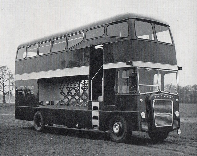
@Al S
The Dartford Tunnel buses had no significant Routemaster DNA. They had bodies built by Strachans, mounted on Ford Thames Trader oily bits. Hence, appropriately, they had "Thames" in big friendly letters on the bonnet.
Here's a picture.
Timbo | 03.10.16 - 10:17 p.m. | #
|
Typical, I posted this a day early.
I've now added Sadiq's wishlist of East London crossings (published today as a smokescreen to cover approval of the Silvertown Tunnel).
diamond geezer | Homepage | 04.10.16 - 4:53 p.m. | #
|
|
The tunnel under the Thames from Tate Modern is a EDF one http://www.london-se1.co.uk/news/view/604
Roger | 04.10.16 - 5:16 p.m. | #
|
|
You should add the old City & South London Railway twin tunnels from London Bridge to King William Street. They were certainly there in the early 1980s -- I walked through them on a trip organised by the Greater London Industrial Archaeological Society, getting in and out via a long demolished building about where the Shard is now. I imagine the southern end was damaged or cut when the Jubilee line was built, but there's no reason they would have been filled in.
Alan Burkitt-Gray | 04.10.16 - 7:33 p.m. | #
|
|
Construction of the new Northern line tunnels at Bank will require the old King William Street station site (which is directly under Arthur Street and adjacent to the point where the new tunnel diverges) to be used as part of the worksite. I don't know if that will further curtail the intact section of the CSLR tunnels under the Thames.
Gavin | 04.10.16 - 8:55 p.m. | #
|
|
A day early? I assumed you were helpfully providing the journalists with some copy!
Andrew | 04.10.16 - 11:00 p.m. | #
|
|
And in a brilliant piece of joined up planning, I see that, in addition to the long term closure of Tower Bridge, the Rotherhithe Tunnel will be closed for maintenance tonight.
Timbo | 05.10.16 - 8:39 a.m. | #
|
Here is a link to a news story which I have pasted without any explanation.
http://www.bbc.co.uk/news/uk-england-london-37552446
A fan of the DG blog now resident at City Hall maybe..?
| 05.10.16 - 11:32 a.m. | #
|
Timbo - the closure tonight is only a postponment of the regular Monday closure.
http://www.londontraffic.org/search.php
Messiah | 05.10.16 - 12:12 p.m. | #
|
|
|
TridentScan v2.10.0 | Privacy Policy
|