
please empty your brain below
Up north the main change happened in 1974. I used to live in south Sheffield that was once part of Derbyshire but that changed years before.
I then moved to an area of Stockport which was in Derbyshire until 1974.
I now live in Hadfield which survived becoming part of Tameside and is in the High Peak area of Derbyshire. The next village up was strangely part of Cheshire but was switched to Derbyshire in 1974 when the rest of North East Cheshire became Tameside.
I often wonder how peoples outlook and how they see themselves changes whey they become part of another county ot a city.
» Heritage trail leaflet
» Picture of the old Beckenham town hall with its tower
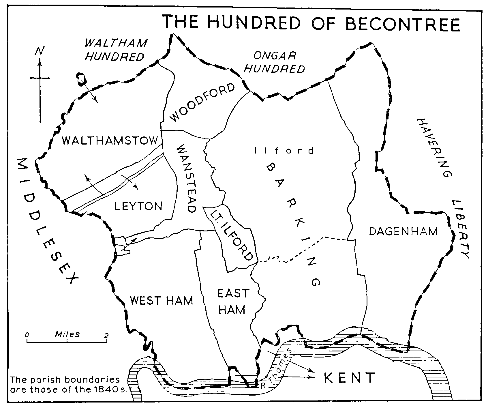
The map showing the parts of Woolwich north of the Thames also shows an exclave of Walthamstow in Leyton, which I've just been looking into. It's origins are unknown - it was possibly the route of a Roman road - but it was apparently known as the 'Walthamstow Slip', and existed until 1885.
There are a few more details here. I'm trying to find a pre-1885 map of the area, because I think I might possibly live in it.
Back to town halls, and to give it a second reference, I grew up in the Metropolitain Borough of Tameside, on the east of Manchester. Tameside was formed of nine different districts.
What always gets me is that a large number of the town halls in Tameside still exist and remain in council use. Denton, Hyde, Dukinfield and Ashton town halls all remain, used for various activities. They're the pride of the town centres they sit in.
Contrast this with Wimbledon where the 1931 town hall is home to a branch of Tesco. It breaks my heart every time I see it.
One final thing on Morden Hall - according to the National Trust there's a plan to re-open the pub. We will see...
You mentioned "Potters Bar in Middlesex escaped, transferring to Hertfordshire", but not the much larger chunk of Middlesex (the Staines/Ashford area) that was adopted by Surrey.
And shouldn't your map show Barnet as having been in Herts rather than Mddx?
Malden & Coombe
Interesting fact about The Maldens & Coombe District Council. It was incorporated in 1936, and its civic mace therefore had the rare distinction of carrying the arms of Kings Edward VIII.
The façade of the town hall is now incorporated into a branch of Waitrose
Sorry, that's the best I can do.
@Andrew B
"Merton's always struck me as a curious choice of name thanks to the modern settlement of Merton being a rather indistinct and unknown thing"
For many people, if it's not on the Tube map it can't really be in London, can it?
@Rick
"Stockport which was in Derbyshire until 1974"
Cheshire, actually.
And people still aren't too sure whether it was intended as a joke or not!
Then last year Bexley moved over the road into the old Woolwich Building Society HQ while the civic centre was bulldozed for a Tesco which will now never come.
https://www.flickr.com/photos/32293736@N04/16393822748
Oh, could you not find one?
"And shouldn't your map show Barnet as having been in Herts rather than Mddx?"
The London Borough of Barnet was formed from districts that were previously in Herts and Middx, so it was a bit of both.
The ambiguous use of a place name to mean both a locality and the much larger London borough in which that locality happens to be causes a lot of confusion. For example, Hanworth is either in Richmond, or eight miles away, for different definitions of "Richmond"
It was mentioned that Surrey CC's offices haven't been in Surrey for 50 years: the same used to apply to Middlesex of course, Middlesex Guildhall being in Parliament Square, and now the home of the Supreme Court.
Looking at the map of the LCC area, I am puzzled as to why it extended so much further downstream on the south bank than the north - why was Woolwich in, but East and West Ham and Barking out?
"Never quite understood why some areas north of the Thames ended up with "south" postcodes..."
Look at a map of Central London and you'll see that the Thames runs from south to east in a large curve - at Westminster it is flowing almost due north. Only the SE quarter of central London is on the Surrey bank.
(At Teddington Lock, it flows almost due west!)
mmm...I see what you mean. So, all of north London is north of the river Thames, but a little of south London is north of the Thames. Must be odd saying one lives north of the river Thames in south London ;)
http://www.francisfrith.com/sutton/sutton-the-municipal-offices-1902_48864
Since demolished and replaced by an 1970s complex (Wilkinson's is now on the site of that picture).
Worth recalling too that although formal integration into London only happened in 1965, most of the outlying boroughs had used London postal districts for many years prior to that.
http://en.wikipedia.org/wiki/London_postal_district#/media/File:Londonpostal_iln_1857.jpg
I think most residents of SW1, SW3, SW5, SW6, SW7 and SW10 would say they lived in West London
Marple Bridge is an area that used to be in Derbyshire.
"The London Government Act 1963 Section 6 (4) provided a mechanism for communities on the edge of Greater London to petition for transfer to a neighbouring county. The legislation required the petition to be submitted between 1965 and 1970, to be signed by more than 300 local electors and for the area to be transferred to have no more than 10% of the borough's local electors. Following this procedure, in 1969 Farleigh was transferred back to Surrey to form part of the Chelsham and Farleigh parish in Godstone Rural District and Hooley became part of Banstead Urban District.
...........only until 1936 when, along with the rest of the parish of Ludworth, it was transferred from the Derbyshire district of Chapel-en-le-Frith to the Cheshire district of Marple (which itself became part of Stockport in 1974).
Closer to home, here have been other boundary changes - when Terminal 4 was built at Heathrow, the Hounslow/Spelthorne boundary ran through the middle, incidentally restoring a Tube service to Surrey for a few years until the boundary was tidied up in 1994.
The external boundary of Greater London has not changed for twenty years, but there have been many changes to the inter-borough boundaries. http://en.wikipedia.org/wiki/List_of_Greater_London_boundary_changes
I knew it was at one point just a couple of generations out.
TridentScan | Privacy Policy