
please empty your brain below
In other words, they were..bastards.
dg writes: True. But, interestingly, only just. The dividing line between the two boroughs runs down the middle of the road outside the station.
If they can't get approval for an upgrade to Camden Town station, to allow for the Northern Line/Southern Line split, would it not be possible to do something at Mornington Crescent?
If you could make the Mornington Crescent the Northern/Southern Line switching point, you could then make Camden Town be open only to passengers going on the Highgate branch, and use Chalk farm for Edgware branch access to Camden?
Mornington Crescent is only on the Charing Cross branch. The City branch tunnels run nowhere near.
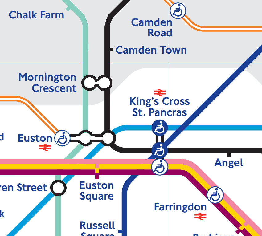
The two bits of the northern line cross over each other at right angles at Euston, but this is typically not shown on diagramatic maps. In theory you do not need to know this unless you are actually digging the tunnels. But of course geographic tube maps do show it - so it's all a bit confusing.
So http://carto.metro.free.fr/cartes/metro-tram-london/ is wrong?
Can you point me to an accurate map please?
Whilst the two branches run near to each other horizontally, there is a fairly big vertical difference – i.e. one branch (the City branch, I think) is higher than the other. It’s a similar situation to that at Camden Town where the NB platforms are higher than the SB. There is also a big gap between branches at the south end of Mornington Crescent (again, like there is at the north end of Camden Town).
Whilst an interchange between the two branches could be made at Mornington Crescent (nothing’s impossible), it would be very expensive to implement. There wouldn’t be cross-platform interchange and interchange between the two branches would involve stairs and possibly a long walk, depending on the arrangements.
It’s also probable that, because of the station tunnels (the lifts are on the Hampstead Road side), it would not be possible to build a SB City branch platform where Mornington Crescent station is, and it would have to be built further south along Hampstead Road where the two branches are further apart. In which case, no doubt both platforms would be built there, with access between the north end of the City platforms and the south end of the CX platforms. Again, a long walk and stairs. In some ways, this would be a simpler solution (if physically possible), but prohibitively expensive.
It would be impossible to split the lines to have the branch junctions south of Mornington Crescent because of the difference in branch height mentioned in the previous post.
The only way to do this would be to realign the City branch so that it curved round earlier to bring it running parallel with the CX branch south of Mornington Crescent. However, I'm certain that this would result in too tight a double curve to be practical. And, of course, cost lots more money than would have been spent at Camden Town.
I thought that the plan was to get rid of the Camden junction?
When the Northern line is split into two, the city branch will always go to Highgate and the west end branch always to edgware.
Thus the need to have a better inter change then at Camden at the moment.
I'm not sure what is unclear. Just build two new platforms around the two "unused" lines at MC and lots of interchange pathways.
Just seems easier to do this where there is lots of open space rather than the busy junction of CT
http://ukfree.tv/styles/images/2013/EXAMPLE.png
It's also wholly delusionally impractical.
It's probably best if we stop playing Fantasy Tube Line at this point.
As far as I recall from reading the "long term plan", the idea is still to split the Northern Line into
Morden-Kennington-Bank-Camden-New Barnet (or MHE)
and
Battersea Power-Kennington-Leicester Square-Camden-Edgware
So that the number of TPH though the two central branches can be increased significantly.
The Charing Cross, Euston & Hampstead Railway (the Hampstead Tube) was part of Charles Yerkes London Electric Railways empire (along with the District, the Bakerloo and the Picadilly (itself cobbled together from a planned extension of the District and two proposed tube lines). The Hampstead line originally ran to Golders Green and to Archway, the former branch later being extended to Edgware.
The CSLR (and the Central) came into the LER fold in the 1920s, after which it was converted to LER standards and extended to Camden Town and Morden, and the Hampstead Tube was extended to Kennington.
The third railway which makes up the Northern Line is a short part of the Great Northern Railway's (later LNER)'s line from Finsbury Park to Edgware (between Highgate and Mill Hill East), together with its branch to High Barnet.
As some will doubtless already know, (and I wouldn't be surprised if DG was going to cover it later this month) the northern Line network at one time included the Moorgate to Finsbury Park line now operated by First Capital Connect, and was to have included the whole of the Mill Hill to Edgware branch, extended to Bushey, and the line from Finsbury Park to Alexandra Palace (High Level) via Highgate
If you have got Google Earth installed, you can see the "Northern Heights" line
Go to "Highgate station", click on the "History" icon and slide the bar to the far left for "1945", as per:
http://ukfree.tv/styles/images/2013/googleearth1945.png
https://en.wikipedia.org/wiki/File:CCE%26HR.png
and
https://en.wikipedia.org/wiki/File:C%26SLR_Route_Map.png
Who was it who took the "City and South London Railway" and the "Charing Cross, Euston and Hampstead Railway" and thought... "Northern Line"?
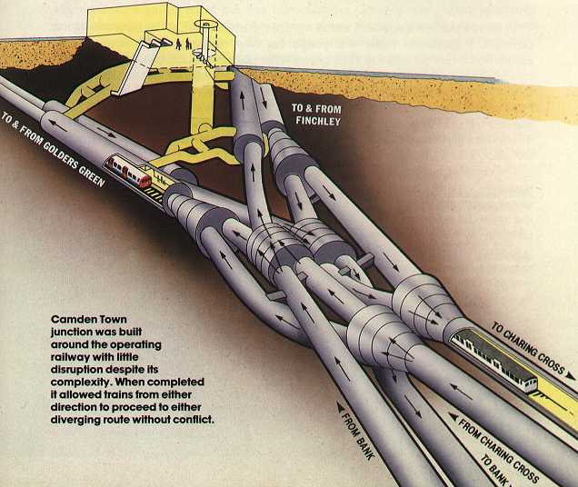
"Amazing Underground Flying And Crossover Junctions"
http://simanaitissays.files.wordpress.com/2013/01/camdentown.jpg
Another 3D cut away
http://husk.org/www.geocities.com/athens/acropolis/7069/ltcamden.jpg
http://www.londonreconnections.com/2013/...
and
http://lurs.org.uk/documents/pdf%2008/july/...
Tomorrow's post can't come quick enough.
At least I'm not mad...
Still not quite satisfied with
"After several rather dubious ideas based on the "Bakerloo" contraction were rejected, it became the "Morden-Edgware Line" on 1934-03-10 before finally gaining its present name on 1937-08-28"
Will have to dig some more.
"Will have to dig some more."
A new extension to the line?
Those two links to drawings of the layout at Camden Town - in one of them the Bank and Charing Cross branches are mislabelled - as has been mentioned, the two branches cross over each other at Euston, so the CX branch is the more easterly one (the left branch as you leave Camden Town)
I can't find the reference now, but recall reading that before the CSLR fell under the wing of the LER, the Metropolitan saw it as a possible way of relieving the twin-track Baker Street- Finchley Road stretch, by extending it beyond Euston under Regents Park to Finchley Road.
In the event, the LER took it over and extended it north rather than west, and it was the Bakerloo (now Jubilee) which was used to tunnel to Finchley Road.
I'm happy about the actual location of the lines. This (as I am 100% sure you know) is a good source:
http://www.subbrit.org.uk/sb-sites/sites/e/euston_station/index.shtml
What I was digging for was the actual details of *how* the name "Northern Line" came about.
Looking around at the other lines, http://en.wikipedia.org/wiki/Central_Line for example, it seems that the name change happened at the same time for both lines.
If the people "in charge" had a list which *already* had "Central" on it, I guess "Northern" is a good fit. Just a guess at this stage.
Even LU's equivalent couldn't get it right, the poster they issued to advertise the opening of the new junction was labelled wrongly, which is no doubt the reason the Eagle (and other diagrams I've seen) also have the wrong labels:
http://tinyurl.com/ccpo2um see bottom of the page.
Original artwork(?) here: http://tinyurl.com/p49ebbe
I’m certain I’ve seen a poster with the junction labelled correctly, so it’s possible that the poster was re-issued.
Franklin uploaded the latest version of the London CartoMetro map - v3.0 - at the weekend (not that there are any changes to the Mornington Crescent or Camden Town layouts, but I know somepeople refer to the map)
TridentScan | Privacy Policy